Report to the Commission: September 23, 2015
Fix the Roads Roundtable
Walnut Creek, August 19
Commissioner Pierce and I were members of a panel of regional and local officials who testified before the special session version of the Assembly Transportation Committee about the importance of repairing our state highways and local roads in California.
Eno Technical Assistance Award
Washington DC, July 7
The Eno Transportation Foundation has awarded MTC a Public-Private Partnership technical assistance award, which will assist us as we roll-out the express lane network in the East and North Bay areas.
Assembly Select Committee Hearing
Oakland, August 21
Vice Chair Mackenzie and I were invited to testify before the first hearing of the Assembly Select Committee on Improving Bay Area Transportation Systems, chaired by Assemblyman Jim Frazier of Oakley. A copy of my fairly wide-ranging presentation can be found here. In particular, I raised the question at the end of my remarks about whether the time had come to begin discussing Regional Measure 3 – the potential successor to the two regional plebiscites that have raised bridge tolls for regional transportation improvements in the bridge corridors.
Sacramento Seminar
San Francisco, September 4
I made brief remarks and participated in a lengthy question & answer session with this group of current and former Sacramento “insiders” where MTC’s founder, the late John Foran, was a long-time member.
San Mateo 101 Forum
San Carlos, September 15
Commissioner Tissier, Andy Fremier and I attended a forum hosted by Assemblyman (and former MTC commissioner) Kevin Mullin about various proposals to improve mobility on the U.S. 101 corridor through San Mateo County. Participants included representatives from several corridor companies, business associations, local and regional transportation officials, and Caltrans.
Megaregion Partnership
Stockton, September 17
Vice Chair Mackenzie and Commissioners Baker, Haggerty and Spering joined MTC senior staff in a “megaregional” meeting with our board and staff counterparts from the Sacramento Area Council of Governments and San Joaquin Council of Governments. This is the third such session we’ve had to discuss transportation and housing issues common to – and overlapping – our three regions. The elected officials present agreed to seek approval from their respective governing bodies to establish this group in a more formal way through adoption of a memorandum of understanding (MOU). The draft MOU will be presented to the MTC Planning Committee in November for consideration.
Beyond Traffic Forum, Sacramento
September 18
At the invitation of the U.S. Department of Transportation, I spoke before a group of state and local transportation officials at CSU Sacramento. The event was part of U.S. DOT’s visioning exercise for their long-range planning initiative about the nation’s mobility trends.
How so many people in the U.S. live in so little of its space
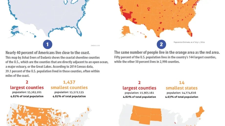
This map series highlights one of the most obvious and surprising facts about where people live in the United States. Most of the U.S. population live together in a few densely populated areas. While this is a well-known fact, visual explanations of this characteristic can be quite striking. These 4 maps illustrate in different ways where we live, and how we actually inhabit so little of our country’s space.
Map 1 shows the coastal shoreline counties of the U.S., which are the counties that are directly adjacent to an open ocean, a major estuary, or the Great Lakes. According to 2014 Census data, 39 percent of the U.S. population lived in those counties, often within miles of the coast.
Map 2 highlights the largest and smallest counties in the U.S. Roughly fifty percent of the U.S. population lives in the country's 144 largest counties, while the roughly other 50 percent lives in 2,998 counties.
Map 3 compares America’s two largest counties (Los Angeles and Cook County) with the 14 smallest states.
Map 4 compares the population of these two counties with 1,437 of the country’s smallest counties. Nearly 5 percent of America's population lives in the counties covering downtown L.A. and downtown Chicago, which is the same proportion as those that live in the country's 1,437 smallest counties.

